Appendix 3: Answers to Lab Exercises
The following are suggested answers to the lab exercises for Labs 1 to 10 in A Practical Guide to Introductory Geology. Answers to the practice exercises are provided in Appendix 2.
Lab 1: Plate Tectonics
Click to view Table 1.1 Answers.
1. Approximate lat/long coordinates of volcanoes along Hawaii-Emperor chain:
- Kilauea Volcano: 19° 24′ 00″N 155° 18′ 00″ W
- Diakakuji Seamount: 32° 8′ 43″N 172° 22′ 39″ E (note that this seamount lies on the opposite side of the 180th meridian from the Kilauea Volcano and Midway Island, and its longitude is therefore described as east)
- Midway Island: 28° 13′ 10″ N 177° 22′ 25″ W
2. Approximate UTM coordinates of volcanoes along Hawaii-Emperor chain:
- Mauna Kea: 5 Q 238012 m E 2185749 m N
- 75.82 Ma volcano near the Detroit Seamount: 58 U 692456 m E 5647840 m N
- 5.77 Ma volcano on Kaua’i: 4 Q 448389 m E 2432911 m N
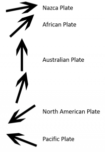
3. Roughly 2,450 km
4. Rate of plate motion: 88.4 km/Ma
5. Rate of plate motion: 8.8 cm/yr
6. The “elbow-like” kink in the Hawaii-Emperor chain is widely ascribed to a change in direction of the Pacific Plate moving over the stationary mantle plume, but a more plausible explanation is that the Hawaiian mantle plume has not actually been stationary throughout its history, and in fact moved at least 2,000 km south over the period between 81 and 45 Ma.
7. 
8. a) and b) are both divergent boundaries.
Lab 2: Mineral Properties and Non-Silicate Minerals
Part I: Cleavage and Fracture
1.
| Sample | M226S | M225S | M1S | M251S | M111S | M223S | M131S |
| Cleavage or fracture | Conchoidal frature | Conchoidal frature | 3 at 90° | 3 not at 90° | *2 not at 90° | Fracture | Fracture |
*Note it can be challenging to see the two cleavage planes in this sample.
2. Not much! Both crystal faces and cleavage planes reflect light well and appear as flat surfaces. Crystal faces may have striations. Remember that cleavage planes (but not crystal faces!) repeat throughout the mineral, so look for the same plane, in the same orientation throughout the sample.
3. Any of the feldspar samples (potassium feldspar or plagioclase) as well as the pyroxene sample also have two cleavage planes at ~90°.
4. Hornblende (amphibole) has two cleavage planes at approximately 56° and 124° (describe this at 2 not at 90° for the purposes of this course).
5. Muscovite and biotite.
6. Curved, smooth. This sample does not exhibit cleavage.
7. Jasper, flint, any quartz sample.
Part II – Non-silicate Minerals
Graphite
1. not often – too soft!, 1 plane
2. H = 1-2
3. low
4. metallic
5. grey-black
6. writes on paper, hardness = 1-2, grey-black streak, greasy feel
Magnetite and hematite
1. no
2. no cleavage
3.
| Sample M51/M52 | Lustre: metallic/sub-metallic |
| Sample M53 | Lustre: dull or earthy |
4. Streak is the same red-brown colour
5. magnetite
6. it is magnetic
7. red-brown streak
Calcite
1. yes, 3 not at 90°
2. H = ~3
3. vitreous
4. yes – vigorously
5. effervesces (reacts) with HCl, H = 3, has 3 cleavage planes not at 90°
Sulphides (pyrite, galena, chalcopyrite, sphalerite)
| Sample M41/M42 | Mineral name: Pyrite |
| Sample M31 | Mineral name: Chalcopyrite |
| Sample M1 | Mineral name: Galena |
| Sample M141 | Mineral name: Sphalerite |
1. All are part of the sulphide mineral group (all mineral formulae end with a sulphur anion (S)).
2. Pyrite may scratch the glass plate, all others are too soft to scratch glass.
3. pyrite
4. Pale yellow colour, strong sulphur smell (smells like rotten eggs)
5. metallic
6. Varies – can be non-metallic (resinous, vitreous, adamantine) or metallic to sub-metallic
7. galena
8. Sphalerite (6 planes!) and galena (3 at 90°)
9. Pyrite is harder, chalcopyrite has a greenish-black streak and tarnishes to bright purple-blue-yellow (peacock-like) colours.
10. High specific gravity
11. Pale yellow streak that smells of sulphur
12.
| Sample # | Mineral Name | Mineral Formula | Ore Metal |
| M1 | Galena | PbS | Pb – lead |
| M31 | Chalcopyrite | CuFeS2 | Cu – copper |
| M141 | Sphalerite | ZnS | Zn – zinc |
13. Galena is the principal ore of lead. Lead is used in lead-acid batteries, as well as in ceramics and glass.
14. Galena is extracted along with any other ore minerals and waste rock from a deposit. Depending on the size, shape, and depth of the deposit, this might be via an open pit mine where ore is accessed from the surface, or via an underground mine where ore is accessed along shafts and levels. The rock extracted from the deposit is ground into a fine powder, and then the material is separated into ore concentrate and tailings (waste). The concentrate is sent to a smelter, the lead-zinc smelter in Trail, B.C., to be refined into pure lead metal. This pure metal can then be sold to manufacturers.
Gypsum
1. H = 2 (scratches with a fingernail)
2. vitreous or satiny, can be silky (selenite variety of gypsum forms as fibrous, silky crystals)
3. H = 2, vitreous or satiny lustre
4. Gypsum is used to make wallboard or drywall. Nova Scotia is the most productive gypsum mining area in the world!
Halides (halite, fluorite)
1.
| Sample M231 | Cleavage: 3 planes at 90° |
| Sample M261 | Cleavage: 4 planes |
| Sample M262 | Cleavage: 4 planes |
2. What is the approximate hardness of the two minerals on the Mohs scale of hardness?
| Halite: H = 3 | Fluorite: H = 4 |
3. fluorite
4. tastes salty, well defined cleavage planes (3 at 90°)
5. H = 4, 4 cleavage planes
6. Hardness test (fluorite H = 4, quartz H = 7), cleavage (fluorite has 4 planes, quartz has no cleavage)
Lab 3: Silicate Minerals
Framework Silicates
1. quartz
2. conchoidal fracture and crystal faces (M221), irregular fracture (M222), conchoidal fracture (M223 and M224)
3. May see striations on crystal faces, cleavage planes (but not crystal faces!) repeat throughout the mineral, so look for the same plane, in the same orientation throughout the sample.
4. H = 7
5. Vitreous
6. H = 7, vitreous lustre, conchoidal fracture
7. Yes, flint also has a hardness of 7 and conchoidal fracture.
| Sample M201 | Mineral name: potassium feldspar (white) |
| Sample M202 | Mineral name: potassium feldspar (pink) |
| Sample M211 | Mineral name: plagioclase (might be albite or labradorite – depends on your kit!) |
1. H = 6 for all feldspar samples
2. 2 cleavage planes at 90° for all feldspar samples
3. Striations on ‘light’-coloured (white) plagioclase feldspar (M211). Iridescence and striations (like the sheen from spilled gasoline in water) on ‘dark’-coloured plagioclase feldspar (M211).
4. Only plagioclase feldspar has striations. Only some potassium feldspar have exsolution lamellae – wavy, irregular ‘veiny’ lines that may appear as a slightly different colour than the rest of the sample (e.g., paler pink, cloudy more opaque white).
Sheet Silicates
| Sample M121 | Mineral name: biotite |
| Sample M271 | Mineral name: muscovite |
1. one perfect ‘basal’ cleavage plane
2. H = 2.5
3. elastic ‘sheets’ that can bend, one perfect ‘basal’ cleavage plane
4. Muscovite is light in colour (almost colourless), biotite is dark brown to black in colour due to iron (Fe) and magnesium (Mg).
| Sample M281 | Mineral name: talc |
5. H = 1
6. pearly or dull
7. H = 1, will leave pale mark on cloth, greasy or soapy feel
| Sample M291 | Mineral name: kaolinite |
8. earthy or dull
9. earthy lustre, smells like clay when wet
Single Chain Silicates (pyroxene family)
| Sample M101 | Mineral name: pyroxene (augite) |
1. 2 at 90°
2. shades of green to almost black
3. colour (shades of green to almost black), 2 cleavage planes at 90°, H = ~5-6
Double Chain Silicates (amphibole family)
| Sample M111 | Mineral name: hornblende |
1. 2 not at 90° (~56° and 124°)
2. greenish-black to black
3. dark colour, 2 cleavage planes not at 90°, H = ~5-6
Isolated Silicates
| Sample M131 | Mineral name: garnet |
1. yes
2. H = 6.5 – 7.5
3. vitreous, sometimes resinous
4. vitreous lustre, no cleavage, hardness = 6.5-7.5, and colour (colour can vary but typically shades of red to red-brown)
| Sample M301 | Mineral name: olivine |
5. H = 6.5 – 7 (difficult to test in some samples due to small size of olivine crystals)
6. sugary, granular (small crystals that look like grains of sugar)
7. colour – pale green to green-yellow
Lab 4: Igneous Rocks
1.
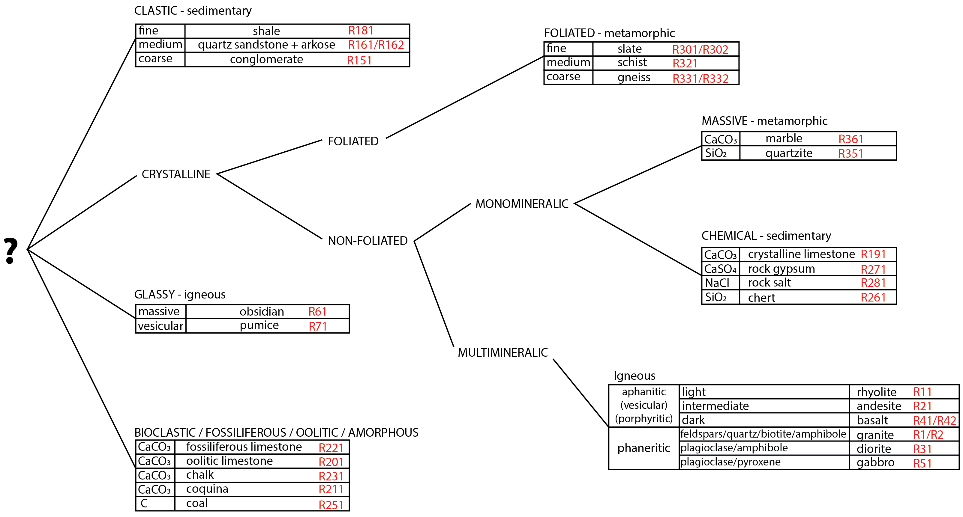
| Sample R2 | Texture: crystalline (igneous rock) |
| Sample R151 | Texture: clastic (sedimentary rock) |
| Sample R281 | Texture: crystalline (sedimentary rock) |
2. The colour of an igneous rock is an indication of its composition (mafic, intermediate, felsic). The composition of the magma controls which minerals will crystallize and the colours of the minerals are reflected by the colour of the rock.
3. Three groups represent phaneritic, aphanitic, and glassy igneous rocks.
4. Grain size is an indication of cooling rate. Larger crystals indicate a slower cooling rate (common for intrusive igneous rocks). Crystals that are too fine to see (forming an aphanitic texture) indicate rapid cooling at or near the surface (extrusive igneous rocks). Rocks with glassy textures and no crystals indicate very rapid cooling or quenching.
| Sample R1 | Rock name: granite (white) |
| Sample R2 | Rock name: granite (pink) |
5. look at a fresh surface
6. crystals
7. K-feldspar (pink), K-feldspar (white), white plagioclase
8. phaneritic
9. similar size, ~1-2 mm
10. light
11. 85-90% non-ferromagnesian, 10-15% ferromagnesian
12. pink or white K-feldspar, quartz, plagioclase (white), ferromagnesian minerals include biotite and/or hornblende (varies by sample)
13. pink K-feldspar
| Sample R11 | Rock name: rhyolite |
14. fresh
15. aphanitic
16. light pink-grey, buff coloured, some samples have flow banding
17. texture (grain size)
18. extrusive (rapid cooling)
| Sample R21 | Rock name: andesite |
19. fresh
20. porphyritic
21. phenocrysts
22. yes on plagioclase and amphibole phenocrysts
23. Some samples have only 1-2 mm laths of white plagioclase (bladed elongate shaped crystals), others have only 3-5 mm amphibole (dark green to black), some may have both.
24. varies with sample
25. intermediate (varying shades of grey)
| Sample R31 | Rock name: diorite |
26. fresh
27. phaneritic
28. no – although size varies depending on which sample you have, within each sample crystals are all of similar size
29. slowly (intrusively)
30. plagioclase, amphibole, +/- quartz, biotite
31. ~50% non-ferromagnesian, ~50% ferromagnesian
32. yes, white plagioclase and amphibole
33. intermediate in colour, black and white rock, no pink minerals
| Sample R51 | Rock name: gabbro |
34. fresh
35. phaneritic
36. yes, plagioclase (may be dark grey in colour and difficult to tell apart from pyroxene!), pyroxene
37. 10-20% non-ferromagnesian, 80-90% ferromagnesian
38. mineralogy, different minerals give each sample a different appearance (colour). R1 is light in colour (felsic), R31 is intermediate, and R51 is dark in colour (mafic).
| Sample R41 | Rock name: basalt |
39. aphanitic
40. no
41. dark grey to black
42. extrusive, aphanitic texture implies rapid cooling at or near the surface
43. texture (grain size), and therefore cooling history. R51 is phaneritic while R41 is aphanitic.
| Sample R42 | Rock name: vesicular basalt |
44. aphanitic and vesicular
45. vesicles. Formed from mafic lava flowing on the surface that cools rapidly as gases escape, leaving gas bubbles preserved in the basalt.
46. texture – one is vesicular and the other is not
| Sample R61 | Rock name: obsidian |
47. glassy, looks like a piece of broken glass
48. no
49. conchoidal fracture
50. Both are glassy, however pumice appears frothy as it consists of small shards of glass welded together with many vesicles whereas obsidian looks like a solid, massive piece of glass. There is also a colour difference: obsidian is dark brown to black in colour whereas pumice is pale in colour (may be white, grey, buff, or tan).
Lab 5: Sediments and Sedimentary Rocks
1.
| Sample # | Grain Size (mm) | Energy Level | Roundness | Sorting | Composition (grains and cement) | Rock Name |
| Example | 0.5-2 mm (sand) | Moderate | Sub-rounded | Moderately sorted | 65% quartz grains, 35% rock fragments, calcite cement | Lithic arenite |
| R151 | Varies with sample, but generally ~3 mm to 8 mm
|
High |
Sub-rounded to rounded
|
Poor to very poor | Larger grains: chert and quartz, Matrix: quartz, silica cement | Conglomerate |
| R161 | one dominant size
1/16 mm to 1/4 mm, up to 2 mm in some samples
|
Moderate to high |
Sub-rounded to rounded
|
Well sorted | > 90% quartz grains, variable cement composition | Quartz sandstone (arenite) |
| R162 | 1/16 mm to 2 mm (varies by sample)
|
Moderate to high |
Sub-angular to sub-rounded
|
Moderately sorted | ~70-80% quartz grains, ~20-30% feldspar fragments (varies by sample), variable cement composition | Feldspathic arenite (arkose, arkosic arenite) |
| R181 | grains are too small to be seen with hand lens
|
Low | grains are too small to be seen with hand lens
|
Well sorted | Too fine to see, but dominated by clay minerals with minor quartz | Shale |
2. All four samples are detrital (clastic) in origin. In all but R181 the clasts or grains are large enough to see that the rock clearly has a clastic texture consisting of fragments of pre-existing rocks or minerals cemented together to form a clastic sedimentary rock.
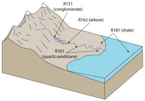
3. Note that this is a generalized diagram and other correct answers are possible. The key is to clearly show that:
- the conglomerate formed in a high energy environment (e.g., a fast-flowing stream near the mountains),
- the arkose and quartz sandstone formed in a high to moderate energy environment (e.g., a stream channel),
- the arkose is less well sorted and contains more angular grains than the quartz sandstone, suggesting that it formed closer to the source of the sediment (i.e., grains have not travelled as far as for the quartz sandstone).
- the shale formed in a low energy environment (e.g., floodplain around a meandering stream, floodplain around stream channels in a delta, in the lake).
4. a) The source material (granite) is the same for both samples, consisting of quartz, feldspars, and some ferromagnesian minerals (biotite or amphibole). Quartz mechanically weathers to form finer grains of quartz. Feldspar minerals chemically weather to produce clay minerals and K+, Ca+2, and Na+ ions in solution. Biotite and amphibole (if present) also chemically weather to produce chlorite (eventually clay minerals), and iron and magnesium ions in solution.
b) Mechanical weathering, and later erosion and transport, break the granite into smaller fragments. Chemical weathering acts primarily on the ferromagnesian and feldspar minerals as these are relatively unstable at the Earth’s surface. Increased transport typically results in better sorting of grains and in increased rounding. The feldspathic sandstone (R162) still contains feldspar fragments that are sub-angular, suggesting that it has experienced less transport and less chemical weathering than the quartz sandstone (R161), in which unstable minerals have been weathered out leaving predominantly well sorted rounded quartz grains.
5.
| Composition | Mineral Name | Rock Sample # | Rock Name | Diagnostic Properties Common to Both Rock and Mineral |
| CaCO3 | Calcite | R191
R201 R211 R221 R231 |
Crystalline limestone
Oolitic limestone Coquina Fossiliferous limestone Chalk |
Hardness ~ 3, reaction with dilute HCl |
| SiO2 | Quartz | R261 | Chert | Hardness ~ 7, conchoidal fracture |
| NaCl | Halite | R281 | Rock salt | Hardness ~ 3, cleavage planes (3 at 90°), cubic crystals, vitreous lustre |
| CaSO4·H2O | Gypsum | R271 | Rock gypsum | Hardness ~ 2, pale colour (white, grey, buff), dull to satiny lustre |
| C (mostly) | N/A | R251 | Coal | Soft, dark grey to black colour, low specific gravity |
6. well-rounded, oval to almost spherical
7. oolitic
8. Concentric layers of calcite precipitated from warm, tropical ocean water around a nucleus (e.g., shell fragment, grain of quartz sand, etc.) and rounded by constant motion in shallow wave-agitated water.
9. Oolitic limestone
10. shells and shell fragments
11. calcite (shells)
12. Both contain evidence of living organisms (shells), both are composed primarily of calcite and therefore both react with HCl. Coquina is distinguished by poorly cemented shell fragments that create a weak, somewhat crumbly rock. Fossiliferous limestone is a much more competent (i.e., stronger) rock. Fossiliferous limestone can contain a wide variety of fossils, including shells or any number of other organisms whose skeletons are made of calcite.
13. Broken up shells of microscopic organisms cemented together are inherently not as “hard” or as resistant to scratching as a large, solid crystal of calcite.
14. Coal
15. From accumulated plant matter in swamps and bogs, where decaying organic matter is buried and heated to form peat and eventually coal.
16. Rock salt: vitreous, cubic crystals (3 cleavage planes at 90°), pale white or pink to colourless translucent or transparent crystals, tastes salty. Rock gypsum: buff-grey or white in colour, generally opaque to semi-transparent, may have “chickenwire” structure.
17.
| Sample | Environment of deposition | Evidence |
| R151 | Fluvial (river) or glacio-fluvial, sub-marine fan | Rounded rock fragments, gravel size requires relatively high energy to transport, poorly sorted |
| R161 | Fluvial (river), beach, lacustrine, aeolian, deltaic, lagoonal, tidal, shallow water marine | Rounded quartz sand requires moderate to high energy to transport, well sorted suggesting relatively long transport (other components like feldspars have been weathered out) |
| R181 | Fluvial (flood plain), lacustrine, evaporite, deltaic, tidal, deep water marine | Well sorted clay-sized particles require low energy conditions to be deposited |
| R281 | Evaporite | Composed of halite, which forms from evaporation of surface water in arid regions |
| R221 | Reefs, lagoonal, shallow water marine | Water is shallow enough for carbonate-shelled organisms to thrive |
Lab 6: Metamorphic Rocks and the Rock Cycle
1.
| Name of protolith | Name of metamorphic rock | Observations (how does the metamorphic rock differ from its protolith?) | |
| Pair A | Fossiliferous limestone (R221) | Marble (R361) | Marble is crystalline and coarser grained (calcite crystals are large enough to see glints of light off of cleavage planes), marble does not contain any fossils. |
| Pair B | Shale (R181) | Slate (R301) | Slate is slightly harder and has a slightly shinier lustre than the shale, which is dull. Depending on the slate sample there may be a difference in colour. May see slaty foliation (absent in shale). |
| Pair C | Granite (R1) | Gneiss (R331) | Gneiss has a gneissic foliation (minerals are aligned and segregated into light- and dark-coloured bands). |
| Pair D | Quartz sandstone (R161) | Quartzite (R351) | Quartzite is often harder than sandstone, as the quartz crystals are “welded” together during recrystallization. Quartz crystals may be coarser grained (larger) than in sandstone protolith (depends on the sample!). Quartzite has a sugary (granular) appearance. |
2.
| Changes in mineralogy | Changes in texture | |
| Shale to slate
(R181 to R301/R302) |
Microscopic mica minerals start to grow from clay minerals
Fluids may add silica (quartz, SiO2) to slate, making it slightly harder and stronger than shale Colour may change depending on composition of protolith (red – oxidized iron, grey – organic carbon forming graphite) |
Slaty foliation (slaty cleavage) develops from alignment of microscopic mica crystals (mica minerals control how the slate breaks into thin sheets)
Smooth, flat surfaces of the slaty foliation may have a slight sheen (may be slightly shinier than the shale) If the shale protolith contained any fossils, these are generally not preserved in the slate |
| Slate to schist
(R301/R302 to R321) |
Mica minerals (biotite and muscovite) continue to grow into larger crystals that are easily identified with the naked eye
New metamorphic minerals may form but are dependent on the composition of the protolith and on the pressure – temperature conditions of metamorphism (e.g., garnet, andalusite, kyanite, staurolite, magnetite) |
Generally, all minerals present are coarser grained than in slate
Mica minerals are coarse grained and easily seen – they give the rock a glittery, shiny appearance. Alignment of mica minerals defines a strong schistose foliation. New minerals that do not have elongate or sheeted crystal shapes (e.g., garnet) do not align with the schistose foliation, and may stand out as “bumps” Foliation may be folded or wavy (crenulated) |
| Schist to gneiss
(R321 to R331/R332) |
Muscovite has disappeared, biotite may also have disappeared
Amphibole or pyroxene has formed from the breakdown of biotite New metamorphic minerals may form but are dependent on the composition of the protolith and on the pressure – temperature conditions of metamorphism (e.g., sillimanite) |
“Shiny, glittery” appearance of schist is lost due to loss of mica minerals
Segregation of ferromagnesian and non-ferromagnesian minerals into bands defines strong gneissic foliation Quartz and feldspar crystals have increased in grain size (were also present in schist but may have been less obvious compared to the abundant, coarse grained micas) |
3.
| Sample # | Approx. temperature (°C) | Approx. Depth (km) | Metamorphic Grade (low, intermediate, high) |
| R301 | 150-300°C | 2 to 5 | very low |
| R321 | 450-550°C | 8 to 12 | intermediate |
| R332 | Above 550°C | 12 to 17 | high |
4. R351 – quartzite and R361 – marble
5. Crystalline
6. Hardness ~ 7 (harder than streak plate, harder than steel knife)
7. Quartz
8. Hardness ~3 (harder than a fingernail, softer than a penny)
9. Rock reacts vigorously with HCl
10. Calcite
11. Yes – broadly speaking they have the same mineral composition. There may be small differences if, for example, the protolith was not a pure calcite limestone or a pure quartz sandstone. Textures have changed and in both cases grain size has increased as a result of metamorphism. The limestone protolith could have exhibited a number of textures (crystalline, oolitic, fossiliferous, bioclastic), but the resulting marble is always crystalline. Quartz sandstone has a clastic texture that recrystallizes to form the crystalline quartzite.
12.
| Order | Rock Name | Sample # | Rock Cycle Processes Responsible |
| 1 | Basalt pebbles (sediment) | N/A | Partial melting of the mantle generates mafic magma. Magma rises and erupts at or near the surface, forming basalt (an extrusive mafic igneous rock). Basalt is mechanically weathered to form pebble-sized clasts that may be eroded and transported. |
| 2 | Shale | R181 | Basalt pebbles are further mechanically and chemically weathered. Ferromagnesian minerals and plagioclase feldspar in the basalt chemically weather to form clay minerals and ions in solution. Clay minerals are transported, and eventually deposited in a very low energy environment. Clay minerals and other silt- and clay-sized clasts are lithified into shale through burial by other sediments, compaction, and cementation by mineral(s) precipitated from a fluid. |
| 3 | Garnet gneiss | R332 | Shale undergoes regional metamorphism to form a high grade metamorphic rock. As pressure and temperature increase, clay minerals become unstable and transform into mica minerals and then into amphibole or pyroxene, garnet, and feldspar minerals. Grain size increases with increasing metamorphic grade. Under directed pressure and shear stress, minerals align to form a foliation and segregate into bands of ferromagnesian and non-ferromagnesian minerals (gneissic foliation). |
| 4 | Diorite | R31 | Gneiss continues to be subjected to increasing temperature and/or pressure until it begins to partially melt, forming migmatite. As melting continues, eventually enough melt is generated to form an intermediate magma that rises through the crust. Magma cools and crystallizes at depth to form diorite, an intermediate intrusive igneous rock. |
Mineral and Rock Review
| Mineral or rock name | Rock or mineral? | If it’s a mineral, which group does it belong to? If it’s a rock, what type is it? |
|---|---|---|
| Feldspar | Mineral | Framework silicate |
| Calcite | Mineral | Carbonate |
| Slate | Rock | Metamorphic (low grade, mudrock protolith) |
| Hematite | Mineral | Oxide |
| Rhyolite | Rock | Igneous (extrusive, felsic) |
| Sandstone | Rock | Sedimentary (clastic) |
| Diorite | Rock | Igneous (intrusive, intermediate) |
| Olivine | Mineral | Isolated silicate |
| Pyrite | Mineral | Sulphide |
| Quartzite | Rock | Metamorphic (massive, sandstone protolith) |
| Granite | Rock | Igneous (intrusive, felsic) |
| Amphibole | Mineral | Double chain silicate |
| Conglomerate | Rock | Sedimentary (clastic) |
| Chert | Rock | Sedimentary (chemical) |
| Halite | Mineral | Halide |
| Gneiss | Rock | Metamorphic (high grade, sedimentary or igneous protolith) |
| Mica | Mineral | Phyllosilicate (sheet silicate) |
| Pyroxene | Mineral | Single chain silicate |
| Chlorite | Mineral | Phyllosilicate (sheet silicate) |
| Limestone | Rock | Sedimentary (chemical) |
| Andesite | Rock | Igneous (extrusive, intermediate) |
Lab 7: Relative Dating and Geological Time
1.
| Rock Type | Granite | Sandstone | Limestone | Shale |
| Origin | Intrusive igneous rock – formed from cooling magma deep beneath the surface of the Earth. | Clastic sedimentary rock – formed from the deposition of sand-sized grains in a moderate to high energy environment. | Chemical (or biochemical) sedimentary rock – formed either from chemical precipitation of calcite or from accumulated organisms with shells made of calcite. | Clastic sedimentary rock – formed from the deposition of clay-sized grains in a low energy environment. |
2.
| Youngest Event | Road Cut A (left) | Road Cut B (right) |
|
||
|
|
|
|
|
|
|
|
|
|
|
|
| Oldest Event |
|
|
3. No, they do not share the same geologic history. The timing of the granite intrusion is different: in Road Cut A the granite is the oldest rock, whereas in Road Cut B the granite is at least younger than the lithification of the sandstone. The exact placement of the granite in the geologic history for Road Cut B is somewhat flexible based on the evidence presented: it could have intruded any time after the lithification of the sandstone and before the uplift and erosion to present day.
4. The principle of inclusions. In Road Cut A, the granite is the oldest rock because the overlying sandstone contains inclusions of granite. Based on the principle of superposition, we know that the sandstone is the oldest sedimentary rock and therefore the granite must be even older than the sandstone. In Road Cut B, the granite contains inclusions of the sandstone, meaning that the sandstone existed before the granite intrusion. This implies that the granite intruded up into the sandstone, and fragments of sandstone rock fell into the magma chamber.
5.
| Youngest Event | Geologic History of Figure B | Justification (which principle of stratigraphy did you use?) |
|
|
|
|
|
|
|
|
|
|
|
|
|
|
|
|
|
|
|
|
|
|
|
|
|
|
|
| Oldest Event |
|
|
6.
| Youngest Event | Geologic History of Figure C | Justification |
|
|
|
|
|
|
|
|
|
|
|
|
|
|
|
|
|
|
|
|
|
|
|
|
| Oldest Event |
|
|
7. Figure illustrates a sequence of faulted sedimentary strata and an igneous dyke. The oldest event illustrated in Figure D is the deposition and lithification of conglomerate during the Pennsylvanian. The conglomerate is overlain by shale, deposited and lithified in the Permian. A disconformity separates the Pennsylvanian and Permian strata from the overlying Jurassic shale. This disconformity likely represents a period of uplift and erosion of any sediment deposited during the Triassic. Following the deposition and lithification of the Jurassic shale, sandstone was deposited during the Cretaceous. At some time following the deposition of the sandstone, an igneous dyke intruded and cross-cut the older sedimentary strata. Later, a fault cross-cut all units. Continued uplift and erosion exposed these units at the surface.
8.
| Youngest Event | Geologic History of Figure E | Justification |
|
|
|
|
|
|
|
|
|
|
|
|
|
|
|
|
|
|
|
|
|
|
|
|
| Oldest Event |
|
|
9.
| Youngest Event | Geologic History of Figure F | Justification |
|
|
|
|
|
|
|
|
|
|
|
|
|
|
|
|
|
|
|
|
|
|
|
|
|
|
|
| Oldest Event |
|
|
Lab 8: Mapping Fluvial Landscapes
Please consult your instructor for feedback on your map.
- NTS map sheet 82 J/16.
- NTS map sheet 82 O/1.
- UTM zone 11 grid lines are blue.
- Contour lines are brown.
- The contour interval is 20 m.
- The topography in the western part of the map is relatively steep whereas the topography in much of the northeastern parts of the map is fairly gentle. Steep topography is indicated by closely spaced contour lines. Gentle topography is indicated by widely spaced contour lines.
- Sketch should show stream flowing from higher elevation contour line toward lower elevation. All contour lines that cross the stream form a “V” shape that points upstream.
- The fastest water flow on a straight stretch of a stream will be in the middle of the stream near the surface.
- 1 millimetre sand grains will be eroded if the velocity if over 20 centimetres per second and will be kept in suspension as long as the velocity is over 10 centimetres per second.
- A braided stream can develop where there is more sediment available than can be carried in the amount of water present at the rate at which that water is flowing. This may happen where the gradient drops suddenly, or where there is a dramatic increase in the amount of sediment available (e.g., following an explosive volcanic eruption).
- The variable water colour is a result of the sediment in suspension and its effect on how light interacts with the water. Where the water is carrying fine grained sediments in suspension the water appears paler in colour. Where there is little sediment in suspension (i.e., where most sediment had already settled out of the water column and has been deposited) the water appears darker in colour. The amount of sediment in suspension decreases as you move away from the mouth of the Elbow River and further into the Glenmore Reservoir, and therefore there is a gradual change in the water colour.
- Factors or forces that influence the behaviour of the Elbow River include but are not limited to: changes in base level (in this case, the water level in the Glenmore Reservoir that is controlled by the dam), changes in discharge associated with seasonal variations or weather events, changes to the vegetation that stabilizes the river banks, and engineered changes to the flood plain (e.g., to build the new Ring Road).
Lab 9: Structural Geology Part I
1. Answers may vary.
2. Different colours map represent different rock types (different lithologies), or simply different compositions (e.g., white quartz sandstone cemented with silica vs red quartz sandstone cemented with hematite). Different colours may also indicate a difference in how adjacent rocks are weathering in response to chemical weathering (e.g., the rusty red staining of rocks containing and/or stained by iron oxide or hydroxide minerals).
3. This area has very little overburden (e.g., soil, glacial till) and very sparse vegetation, meaning that the exposure of bedrock at the surface is excellent. Furthermore, there are strong colour contrasts between the different units that are easily visible in satellite imagery. The areas around Calgary and Vancouver have very little exposure of bedrock at the surface, and are largely covered with overburden, vegetation, and infrastructure. Most areas in Canada, with the exception of some steep mountains and coastal areas, are not well suited to this type of activity using satellite imagery.
4. Feet.
5. C.I. = 40 ft
6. Topographic contour lines are deflected to form a “V” shape as they cross a stream. The point of the “V” shape always points upstream.
7. Contour lines are approximately parallel to the contacts between the layers of rock in the immediate area around the place marker for Raplee Anticline.
8. The layers of rock in the immediate area around the place marker for Raplee Anticline are approximately horizontal.
9. You would be walking through progressively older rocks. You are starting from the “top” of the pile at the place marker for Raplee Anticline, and as you walk down the slope, over the horizontal layers of rock, you are walking “back in time” following the principle of superposition.
10. No, these strata are not horizontal. The contacts between the layers here form jagged “V” shapes that cross the topographic contour lines at a high angle, indicating that these layers are dipping. If these layers were horizontal their contacts would be parallel to the contour lines, much like they were around the place marker for Raplee Anticline. If these layers were vertical, their contacts would not be deflected at all by the contour lines – they would cut straight across the topography.
11. Using the 3D capabilities of Google Earth Pro (and in plan view, using the Rule of V’s) we can confirm that these layers are dipping.
12. Dip direction (using the Rule of V’s): W (west)
13. Dip direction: SE or ESE (either are acceptable here as we are just estimating)
14. Dip direction: N
15. Rocks of different colours in the satellite imagery correspond to different mapped units on the geological map. Bedrock map units are shown by coloured polygons with map codes. Notice that some mapped units (e.g., unit Km) include layers of rocks with variable colours. Recall that most geological maps do not map each individual rock type, but instead describe rocks together as formations or groups. Note that the satellite imagery and the units on the map may not line up perfectly as the geological map is not “pinned” directly to the ground in Google Earth.
16. Answers may vary. Some examples are listed below.
- Unit Pp (Phosphoria Formation), in the NE corner of the map, dip direction: WSW to SW
- Unit Pt (Tensleep Sandstone), in the NE corner of the map, dip direction: WSW to SW
- Units Kf (Frontier Formation) and Kc (Cody Shale), near 44° 35′ 03″ N 108° 09′ 33″ W, dip direction: SW
17. Geologic Map of Sheep Canyon Quadrangle, Wyoming
18. Robert E. Ladd
19. 1 : 24,000
20. 1.6 km
21. Map code, colour of unit on the map, full unit name, age, description of lithology(ies), thickness. Note that not all geological maps include unit thickness in the legend.
22. Oldest at the bottom, youngest at the top.
23. Unit Mm, Madison Limestone, Mississippian, limestone and limestone breccia.
24. Exposed up in the NE corner of the map.
25. Unit Twl, Willwood Formation, Eocene, siltstone and sandstone. Note that while there are younger materials on this map, carefully reading the legend reveals that these are not formations because they are not yet rocks! The younger Quaternary units are deposits of unconsolidated sediments.
26. Exposed up in the SW corner of the map.
27. Unit Pt (Tensleep Sandstone) and Unit PMa (Amsden Formation; deposited during the Mississippian and Pennsylvanian). Amsden is the oldest of the two.
28. Phosphoria and Gypsum Spring formations, as they contain thickly-bedded and massive gypsum, respectively. Possibly also the Dinwoody Formation, although mining thin stringer veins is unlikely to ever be profitable for an industrial mineral like gypsum.
Lab 10: Structural Geology Part II
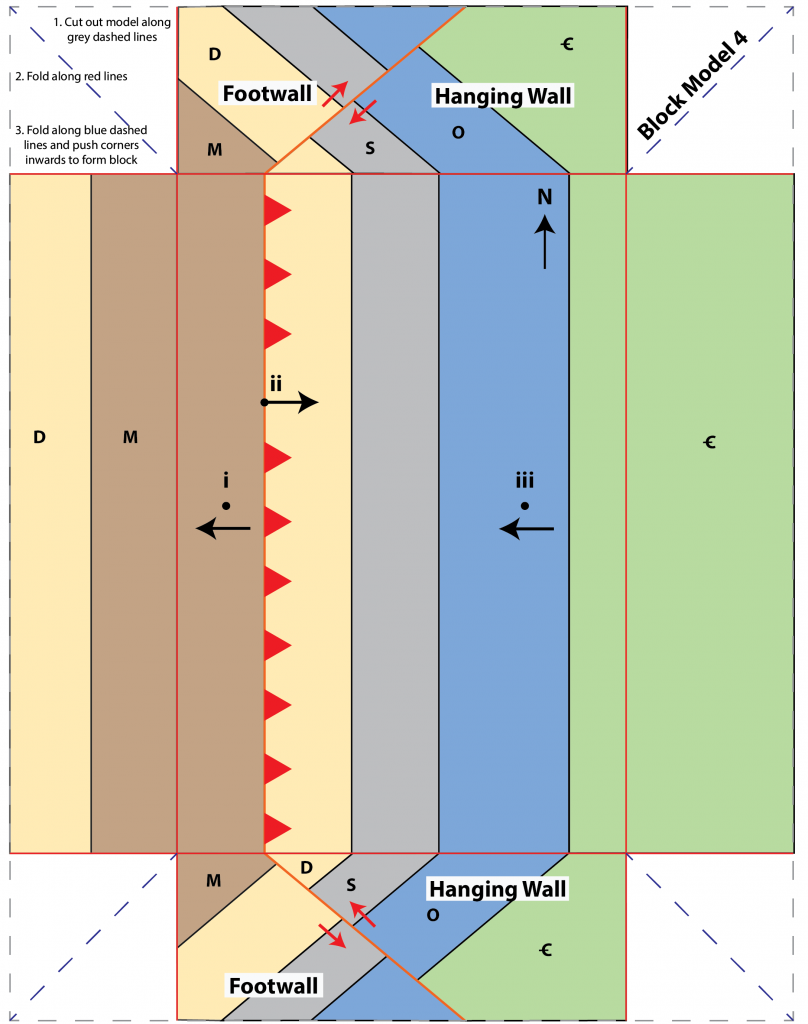
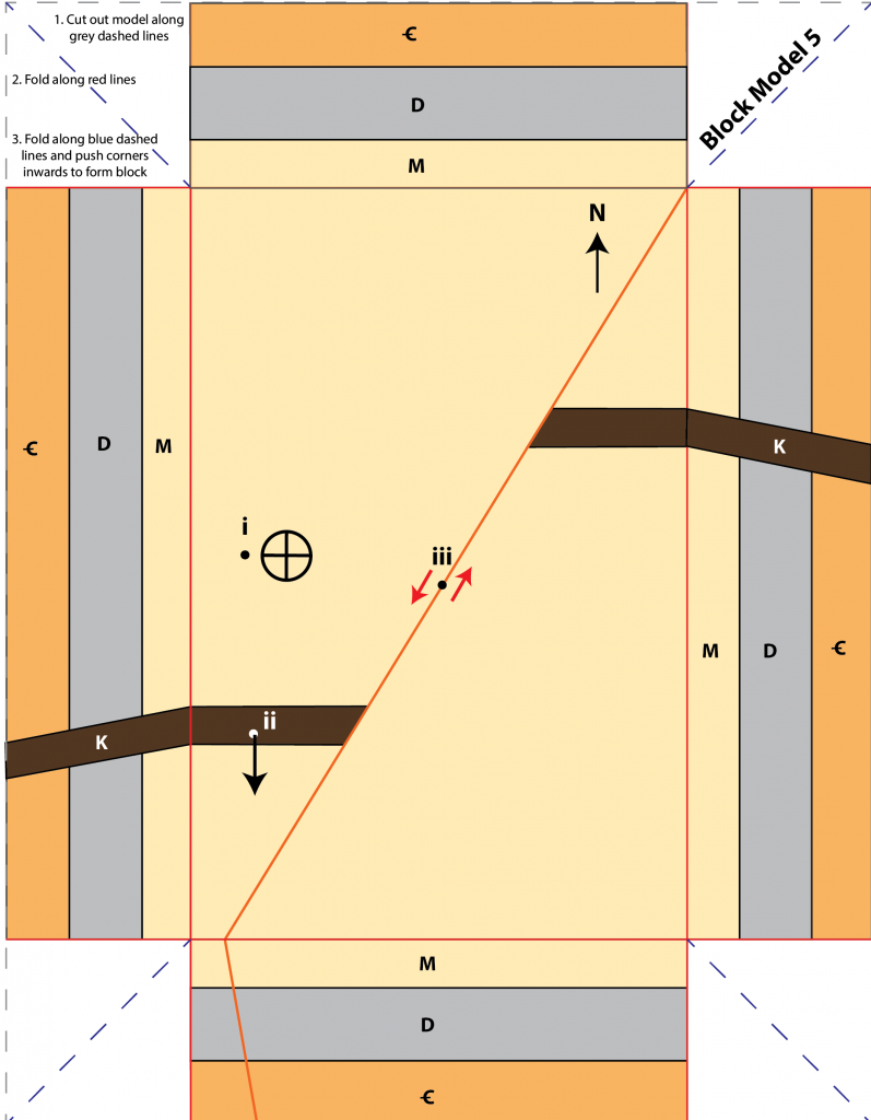
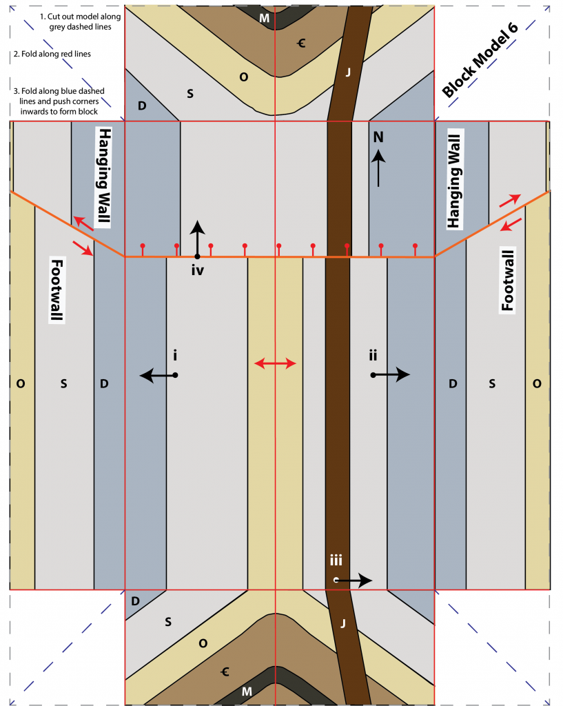
Block model keys are not provided. Consult your instructor for feedback on your completed block models.
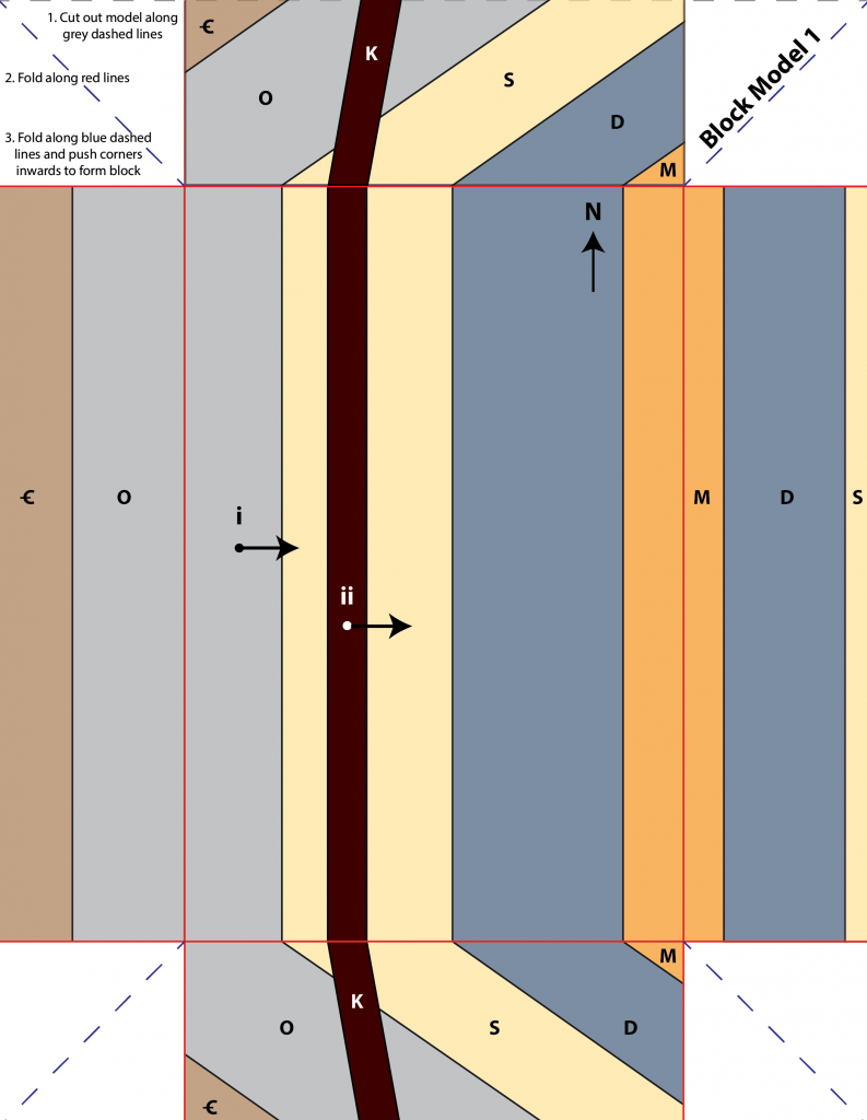
Block Model 1
3. Dip of Ordovician: 35°
5. Dip of dyke: 80°
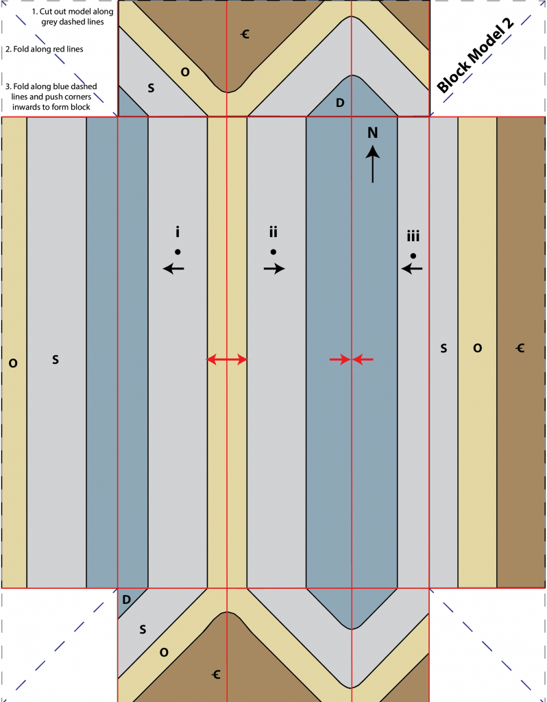
Block Model 2
5. Compressional stress.
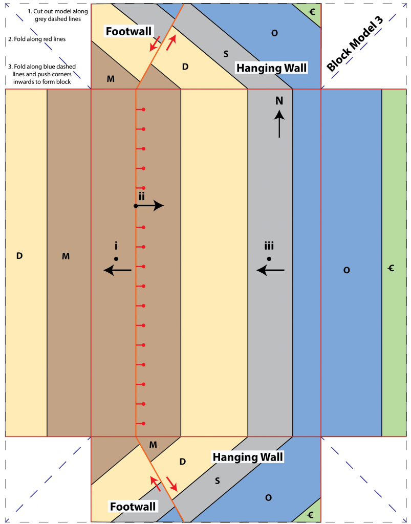
Block Model 3
7. Normal fault. Hanging wall has moved down relative to the footwall.
9. Tensional stress (extension).
Block Model 4
7. Reverse fault. Hanging wall has moved up relative to the footwall.
9. Compressional stress.
Block Model 5
2. The Mississippian formation is horizontal at point i, it is not dipping (dip of 0°).
3. Dip: 80°, Dip direction: south (S)
4. Red arrows should indicate that dyke has been displaced along a left-lateral strike-slip fault.
5. Left-lateral strike-slip fault, looking across the fault the dyke appears to have been displaced to the left and there is not vertical offset of any other units.
6. Point-form geologic history (oldest event at the bottom, italic font indicates principle used to justify position of event in the timeline):
- All units cut by left-lateral strike-slip fault (cross-cutting)
- Intrusion of Cretaceous dyke (cross-cutting)
- Deposition and lithification of Mississippian formation (superposition)
- Deposition and lithification of Devonian formation (superposition)
- Paraconformity – period of non-deposition and/or erosion – missing Ordovician and Silurian (superposition)
- Deposition and lithification of Cambrian formation (superposition)
7. Shear stress.
Block Model 6
2. Arrows should indicate that the Silurian formation is dipping toward the following directions:
- Point i: W, Dip: 38°
- Point ii: E, Dip: 37°
5. Dip: 80°, Dip direction: east (E)
6. Dip: 60°, Dip direction: north (N)
9. Normal fault. Hanging wall has moved down relative to the footwall. Also, notice that the core of the anticline in the hanging wall block does not expose the Ordovician formation because this block has dropped down.
10. Point-form geologic history (oldest event at the bottom, italic font indicates principle used to justify position of event in the timeline):
- All units cut by normal fault related to extension (tensional stress) (cross-cutting)
- Intrusion of Jurassic dyke (cross-cutting)
- Folding of Cambrian to Devonian strata and Mississippian sill into anticline by compressional stress (original horizontality)
- Intrusion of Mississippian sill (cross-cutting)
- Deposition and lithification of Devonian formation (superposition)
- Deposition and lithification of Silurian formation (superposition)
- Deposition and lithification of Ordovician formation (superposition)
- Deposition and lithification of Cambrian formation (superposition)

