Connectivity
Connectivity is a component of ecosystem integrity that describes how well individuals and populations can move through a landscape (Rudnick et al. 2012). This is an aspect of conservation that applies to all industrial sectors.
The capacity for unhindered movement is needed to support a wide range of biotic processes at multiple scales, including:
- Foraging
- Predator avoidance
- Reproduction
- Dispersal
- Seasonal migration
- Range shifts to accommodate changing environmental conditions
Connectivity may be compromised by physical barriers along important travel corridors. For example, human settlements along river valleys often impede the movement of wildlife, particularly in rugged landscapes where travel alternatives are limited. Dams and roads that bisect watercourses can block the movement of aquatic species. Movement can also be hampered by habitat degradation, which alters movement patterns, slows the rate of movement, and reduces access to certain parts of the landscape (Rudnick et al. 2012). Habitat degradation and fragmentation are most pronounced in the Agricultural South, so this is where the need for management intervention is greatest.
One approach to maintaining connectivity is through broad measures that support wildlife movement across the entire landscape. Some measures focus on maintaining natural ecosystem composition and structure through the application of the natural disturbance model and the proactive control of cumulative effects. Other measures seek to minimize the occurrence of known barriers. For example, road construction can be harmonized between companies to avoid duplication, and water flows can be maintained through proper culvert installation (Robinson et al. 2010). In agricultural regions, farmers can be encouraged to retain riparian habitat and hedge-rows.
Connectivity can also be enhanced through movement corridors (Hilty et al. 2006). In contrast to broad connectivity measures that seek to enhance permeability everywhere, corridors are intended to connect specific parts of the landscape for a specific purpose. A corridor is a type of special management zone in which biotic connectivity is a high management priority.
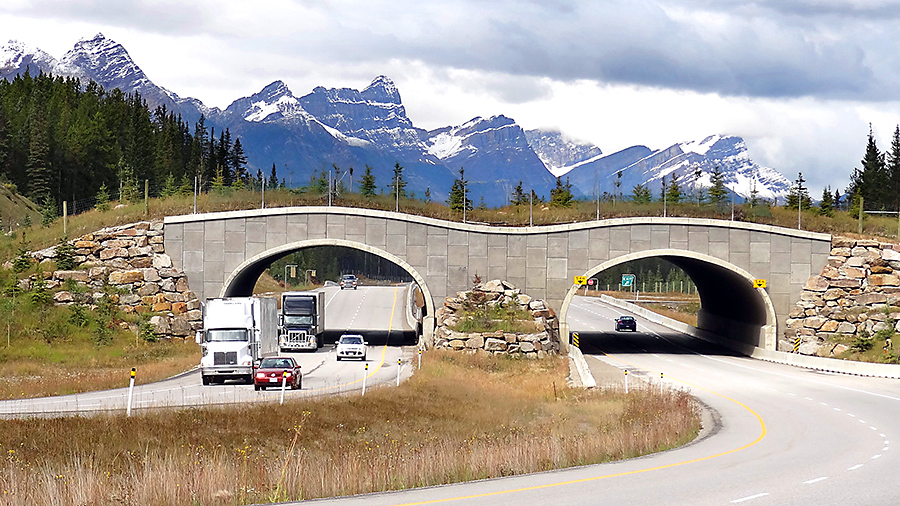
Corridor projects are implemented across a wide range of scales. Short-range corridors are the most common. They are typically used to facilitate movement across barriers such as major roads and dams and to confer protection to highly used travel routes (Fig. 7.16).

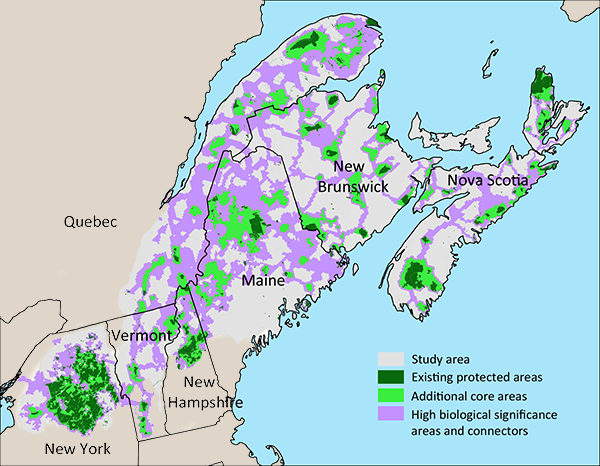
The largest corridors are continental in scope. For example, the Yellowstone to Yukon initiative aims to establish a 3,200 km interconnected system of wild lands along the Rocky Mountains in Canada and the US (Y2YCI 2014). Another high-profile example is the Two Countries, One Forest initiative which seeks to connect and protect forests of the northern Appalachian/Acadian region from New York to Nova Scotia (Fig. 7.17). These long-range initiatives provide an overarching vision and define regional priorities, but actual implementation usually occurs through smaller local projects, where focused operational planning is more feasible (Beier et al. 2011).
 |
Fig. 7.17. The Two Countries One Forest initiative is intended to provide connectivity between the US Appalachian region and Canada’s Acadian region. The proposed design includes core areas and a network of connecting corridors. Source: Reining et al. 2006. |
Established guidelines are available that prescribe optimal crossing placement and construction of small-scale wildlife crossings (e.g., Clevenger and Huijser, 2011). Larger initiatives usually require some form of regional connectivity analysis to determine the best corridor design. A key issue is whether the corridor is to benefit a single focal species or many species. A trade-off is involved because species do not all share the same patterns of movement (Perkl et al. 2016). The more a corridor is tailored to the specific needs of one species, the less it will serve the needs of others (Koen et al. 2014a; Dilkina et al. 2016). Corridors for multiple species demand compromise solutions.
Connectivity analysis draws on the landscape connectivity models we discussed in Chapter 6. When the focus is on a single species, assessments are often based on habitat suitability or known animal movement patterns (Rudnick et al. 2012). When designing corridors for multiple species, assessments are more likely to be based on patterns of landscape intactness (Koen et al. 2014a). For regional-scale initiatives, corridor design should be integrated with protected area planning so that potential trade-offs and synergies between corridors and protected areas can be fully assessed (see Chapter 8). The effects of climate change also need to be taken into account (see Chapter 9).
Another aspect of corridor design is determining the appropriate width. Corridor width depends on the target species, length of the corridor, and its intended function. A linear corridor that is 20–40 m wide may be appropriate for a highway overpass (Clevenger and Huijser 2011), but an effective linkage between two distant protected areas may require a special management zone that is many kilometres wide. The appropriate width for long-distance corridors remains a grey area in the scientific literature, so little reliable guidance is available. Moreover, each case is unique.
Lastly, like other conservation measures, corridors are subject to socio-economic constraints. On public lands, trade-offs with other land-use objectives must be considered. On private land, corridor establishment usually requires land purchases and restoration, which can be costly. Furthermore, the creation of long-distance corridors is logistically challenging, in that it requires coordination across multiple industrial sectors and jurisdictions. Consequently, most movement corridors in Canada have been relatively short-range. The creation of long-distance linkages among protected areas remains more a vision than a reality at present. Initiatives like Yellowstone to Yukon are long-term projects that are being implemented piecemeal, through opportunistic local additions.

