Case Study 6: Reserve Design
Background
This case study examines a planning process intended to guide the establishment of new protected areas in northwestern Alberta. This example illustrates the mechanics of systematic conservation planning, using Marxan, and provides insight into the handling of trade-offs among conservation objectives.
The initiative began in early 2015, motivated by the Alberta government’s stated intention to extend regional planning to northwestern Alberta later that year. It was expected that the new regional plans would include a protected area component, following the precedent set by the Lower Athabasca Regional Plan in 2012 (see Case Study 2). Sensing an opportunity and a need, a group of conservation practitioners decided to conduct a study of regional conservation priorities, as a preparatory step (Schneider and Pendlebury 2016).
The government had not set a target for the amount of protection in the northwest, so the study was designed to be flexible with respect to targets. The group assumed the precedent set by the Lower Athabasca Regional Plan (i.e., 21%) was unlikely to be exceeded and that a lower amount was quite possible. The objective of the study was to determine where new reserves should be located to obtain the maximum conservation benefit, whatever the limit on the amount of protection might be.
There were two main tasks. First, the group had to select the biological entities to be protected. Second, given constraints on the amount of protection possible, the group had to develop efficient reserve designs for representing the selected biological elements.
A technical working group was established to conduct the study. It was composed of conservation scientists from the University of Alberta and representatives from most of the major conservation organizations operating in Alberta. The aim was to have a broad base of conservation expertise to draw on. In addition, the working group was meant to serve as a forum for resolving differences among organizations, so that the conservation community could speak as a single voice when providing recommendations to regional planners.
The working group included a Government of Alberta liaison linked to the regional planning process. Additional representatives from Alberta Fish and Wildlife, Alberta Parks, and the Alberta Biodiversity Monitoring Institute provided information and feedback. The group’s efforts were supported by a grant from Alberta Ecotrust and in-kind contributions from group members and their organizations.
Selection Criteria
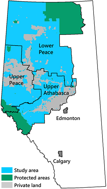
The group decided to combine the province’s three northwest planning regions into a single large study area (Fig. 11.27). They felt this would provide added flexibility for achieving representation targets and result in more efficient reserve designs.
The group’s first step was to review earlier conservation planning efforts. Of particular relevance was the example provided by the Lower Athabasca Regional Plan (GOA 2012). The group assumed that alignment with this plan would be necessary for their recommendations to be seriously considered by regional planners. The Lower Athabasca Regional Plan identified four criteria for the selection of sites:
- Areas that are representative of the biological and landform diversity of the planning region
- Areas with little to no industrial activity
- Areas that are roughly 4,000–5,000 km2 in size (for maintaining ecological processes)
- Areas that support Indigenous traditional uses
The group also reviewed a planning framework developed by Alberta Parks in 2014 (AP 2014). This framework employed a hierarchical coarse-filter approach. It also had a complementary fine-filter component which focused on unique geologic features, rare and localized species, and critical habitat for wide-ranging species. This framework provided a methodology but did not identify preferred sites.
Finally, there were several map products that had been developed to support conservation planning in Alberta. These included a map of Environmentally Significant Areas, commissioned by the Alberta government (FBC 2014), and three maps of conservation priorities developed independently by three conservation groups. Each organization used a different scoring system for assigning conservation priorities.
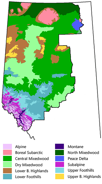
The working group used a combined coarse- and fine-filter approach for its study, consistent with the principles of systematic conservation planning and the Alberta Parks framework. The choice of specific elements reflected the group’s judgment about what was needed to achieve comprehensive representation of biodiversity. The choices were informed by earlier planning efforts and constrained by data availability. The coarse-filter elements included Natural Subregions (Fig. 11.28), major vegetation types, major wetland types, and a land facet layer developed by Dr. Scott Nielsen at the University of Alberta (Michalak et al. 2018).
The fine-filter elements included the habitat of all species of conservation concern for which spatial data were available (n=45). The habitat datasets were obtained from the Alberta Biodiversity Monitoring Program in the form of modelled species distribution maps. The fine-filter elements also included 19 fine-scale wetland classes and the modelled distribution of high-density waterfowl areas, provided by Ducks Unlimited Canada.
Identifying Priority Areas
The working group used Marxan to identify potential reserve configurations (see Chapter 8). A variety of design scenarios were examined to reveal trade-offs among design objectives. Existing protected areas were automatically included in all scenarios. Privately owned lands (Fig. 11.27) were excluded from consideration in accordance with the regional planning process. Because Marxan typically finds many different reserve configurations that work equally well, the model was run 100 times for each scenario. The probability of selection was then calculated for each 500-ha planning unit.
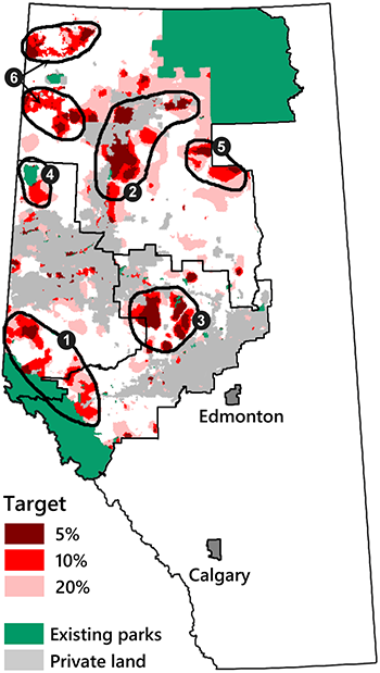
A key challenge was that the government had not yet defined a protection target for the region. The group’s solution was to generate reserve designs across a range of representation targets, from 5–30% of each coarse- and fine-filter element (Fig. 11.29). This way, relevant guidance would be available to regional planners regardless of the overall amount of protection they ultimately decided on.
In the base scenario, Marxan was required to achieve all coarse-filter representation targets while also prioritizing planning units with a low intensity of disturbance and minimizing the total area protected. The proxy for disturbance intensity was the density of linear features, obtained from the Alberta Biodiversity Monitoring Institute. A penalty was applied to the optimization algorithm to encourage the model to select contiguous patches rather than isolated planning units. The base scenario was first run using a 5% representation target for all coarse-filter elements. The process was then repeated with higher targets (i.e., 10%, 20%, and 30%).
The other scenarios were extensions of the base scenario. To begin, the group ran a scenario that included the fine-filter elements, with representation targets matched to the coarse-filter elements. The inclusion of fine-filter elements had no appreciable effect on the designs. This was recognized to be an artifact of data availability. The fine-filter species included in the study were those that the Alberta Biodiversity Monitoring Program had been able to survey. These species generally had broad distributions and were easily represented by the coarse-filter designs. Spatial data for true fine-filter species—those with unique and restricted habitats—were generally unavailable, and so these species were not included. This was acknowledged as a limitation of the study.
The group also explored a scenario that provided enhanced protection for a suite of high-profile species at risk residing in the foothills region east of the Rocky Mountains (i.e., woodland caribou, grizzly bear, Athabasca rainbow trout, bull trout, and Arctic grayling). In this scenario, planning units that contained habitat for three or more of these species were forced into the designs. The analysis showed that this could be done without increasing the overall area of protection. This was because the foothills region was already emphasized in the base scenario as a result of its low level of existing protection (just 1.4%). Prioritizing the species at risk in the foothills required only an adjustment in which specific parts of the foothills would be protected.
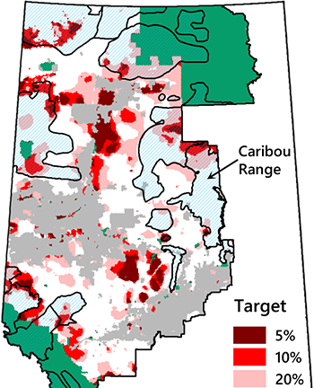
In another scenario, the group explored options for achieving the 65% target for caribou habitat protection prescribed by the federal recovery strategy. Preference was given to caribou habitat with the least disturbance intensity and the highest stability under climate change. In this case, there was a clear trade-off. The areas that were best for caribou did not align well with the areas that were best for representing biodiversity overall (Fig. 11.30). The implication was that, in the face of constraints on the total amount of protection, a choice would have to be made between protecting caribou and protecting overall biodiversity.
Lastly, the group examined a scenario in which Marxan was required to minimize conflicts with resource development while still achieving representation targets. The proxy for resource conflict was the estimated value of oil, gas, and forest resources within each planning unit (Map C in Fig. 11.12). The reserve designs for this scenario were not appreciably different from the base case. This was because resource values and linear disturbances were highly correlated spatially—most of the disturbance footprint was related to access for resource development. By requiring Marxan to avoid linear disturbances in the base model, it avoided areas with high resource potential by default.
Once the scenario analysis was completed, the working group turned its attention to making recommendations. The group recognized that regional planners would need more than just raw Marxan output to work with. A bridge had to be built between the technical analysis and its application in land-use decision making.
The group first developed a composite map of Marxan output for the base scenario with fine-filter elements added. This map illustrated the planning units consistently selected under the different representation targets. Next, the group identified six priority areas for protection (black ovals in Fig. 11.29). This step was needed because the Marxan designs were too fragmented to be used directly in regional planning. The intent was to identify the best sites for establishing large contiguous protected areas, as required to maximize ecological function and to align with the criteria established by the Lower Athabasca Regional Plan.
The group also provided a written description for each of the six priority areas, conveying their individual contributions to the overall system. The group felt that planners and stakeholders needed to understand why the specific sites were necessary and why they were not substitutable. The group also summarized the key findings from their scenario analyses and discussed the limitations of their study.
The group’s final report was released in 2016, 15 months after the study began (Schneider and Pendlebury 2016). The Marxan data files were provided to the government through the government liaison in the working group.
Analysis and Conclusions
This case study provides an example of biocentric reserve planning. The working group had neither the capacity nor the authority to conduct a more comprehensive planning effort involving industry, local communities, and other stakeholders. Social decision making was expected to happen later, through the regional planning process. The group saw its role as preparing a sound foundation for later negotiations by identifying biotic priorities for protection.
This case study illustrates that there is a subjective aspect to setting protection priorities, even within the domain of conservation. Prior to this study, the government and several conservation organizations had prepared assessments of conservation priorities in northern Alberta, and each was distinct. The priority assessments were strongly influenced by the choices each organization made about which aspects of biodiversity to emphasize in its analysis.
A major contribution of this planning initiative was the opportunity it provided for alignment within the conservation community. Coming into the process, individual participants had different ideas about what was important to protect: species at risk, waterfowl and wetlands, old-growth birds, species richness, areas of high endemism, and so forth. As the list of elements expanded, it became apparent to the group that all habitats were important and merited protection.
The desire for comprehensive representation changed the nature of the planning exercise relative to earlier prioritization efforts. It made the coarse-filter approach the obvious foundation for the analysis. The coarse-filter approach was also recognized to be the most robust under climate change. The other major difference from earlier efforts was that this exercise incorporated constraints on the amount of protection. This motivated a search for optimal design solutions using Marxan. In addition, greater consideration was given to trade-offs among representation objectives.
From an ecological perspective, the final design was a compromise solution, as would be expected in the face of area constraints. It provided balanced representation of all elements, but it did not ensure that the critical habitat of all species was protected or that recovery objectives would be achieved. Woodland caribou are a prime example. The base scenario provided some protection of caribou ranges (mostly in existing reserves), but it was far below the level prescribed by the federal species recovery strategy. Shortfalls were also likely in other species, though this was not quantified because critical habitat was not identified for most.
The final design also suffered from a low level of connectivity. Given such a large study area, the priority regions for protection were separated by great distances (Fig. 11.29). The group identified some local opportunities for connectivity in their report, but no solutions were provided for resolving the major disjunctions. Achieving both representation and connectivity would require much greater levels of protection than considered in the study. Alternatively, connectivity could be achieved through special management zones.
These deficiencies need to seen in context. Designing an ecologically optimum reserve system was never the intent of the planning exercise. The aim was to identify conservation priorities, so that any new reserves arising from the regional planning process would be located in areas that provided the greatest conservation benefit. Constructing an ecologically optimum reserve system would require a level of protection substantially greater than the 21% precedent set in the Lower Athabasca Regional Plan.
In the end, the project failed to achieve its goal of guiding protected area planning in northwest Alberta. Even though the working group did everything in its power to align its efforts with the regional planning process, including having a government liaison participate as a group member, its findings never used. Instead, shortly after the group submitted its report, the provincial government announced its intention to protect the range of three caribou herds in northwest Alberta, as part of its caribou recovery efforts (see Case Study 3; Denhoff 2016).
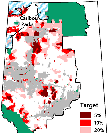
Given limits on the amount of protection that is politically feasible, a decision to focus on protecting caribou leaves less opportunity for protecting sites that benefit biodiversity overall. The three new caribou areas are large, totalling over 15,000 km2, yet they are largely devoid of the high-priority planning units identified in the Marxan analysis (Fig. 11.31). This is exactly the sort of outcome, reflecting a very narrow interpretation of biodiversity, that the working group was hoping to forestall.
We have here an unfortunately clear example of how focal species conservation can undermine efforts to achieve broader biodiversity conservation goals. Political leaders do not have the time or expertise to wade into the nuances of ecological trade-offs. It is much easier for them to latch onto a high profile species and use it as a proxy for biodiversity as a whole. In this case, the derailment of the entire land-use planning process (see Case Study 2) gave added impetus to the search for simple and quick land-use solutions.
This is not to say that promoting the conservation of focal species is necessarily a bad strategy. Without a “poster child” to rally public attention and support, biodiversity conservation initiatives often fail to make progress. Much depends on local circumstances and there is no general rule to follow, except perhaps the old adage: be careful of what you ask for, you might get it.

