8.1 Introduction to Structural Geology
Structural geology is a branch of geology that studies the three-dimensional distribution of rocks and the geometric relationships between rocks. Structural geologists aim to understand the processes that result in the complex geological features we see on Earth today. In this lab, we will explore the foundational aspects of structural geology and how geological maps are used to display structural geological information. We will use block models to introduce the concepts in this section. The top surface of the block represents the surface of the Earth, and the four sides provide four cross-sectional views of the geology in the subsurface.
Fundamental concepts and nomenclature
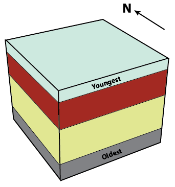
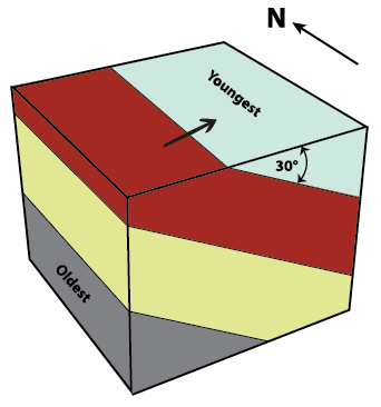
In Lab 5, we discussed how sedimentary rocks form layers as sediments are deposited over time and are eventually lithified into rock. Many sedimentary rocks, as well as some igneous rocks (e.g., those formed from lava flows), form planar layers. A planar layer has flat surfaces above and below it, just like the hard front and back covers of a hardcover textbook. The planar surface between two different layers of rock is called a contact. In the adjacent figures, the black lines represent the contacts between planar layers of rocks. An important note: planar does not mean horizontal. For example, both figures 8.1.1 and 8.1.2 show layers of rock, called strata (plural) or stratum (singular), that are planar. In Figure 8.1.1, these strata and the contacts between them are horizontal, but in Figure 8.1.2 the strata and the contacts are tilted or inclined.


Describing the attitude of a plane: Dip and dip direction

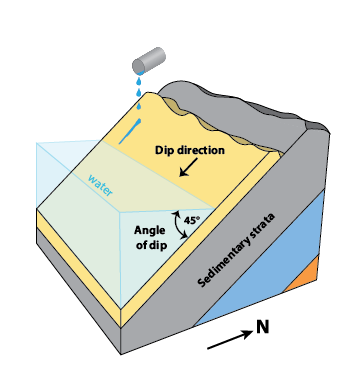
Planar layers of rock can be horizontal (Figure 8.1.1), vertical, or tilted at any angle in between (Figures 8.1.2, 8.1.3). Geologists need to describe the attitude of a layer of rock, meaning exactly how the layer is oriented in three-dimensional space, in order to properly study and map it. Two pieces of information that help describe the attitude of a layer of rock are dip and dip direction.
Dip refers to the angle measured in degrees (°) between horizontal and the tilted plane. Horizontal strata have a dip of 0°, whereas vertical strata have a dip of 90°. Figure 8.1.2 shows strata that are dipping 30°. In a real-world example, you could use a protractor to measure the angle between horizontal and the dipping strata to confirm that the dip is indeed 30°.
To understand dip direction, it can help to visualize pouring a glass of water onto dipping strata, as illustrated in Figure 8.1.3. The water runs down the tilted surface of the stratum in the direction of maximum dip, also known as the dip direction. In this course, we will use cardinal directions (i.e., N, E, S, W) and ordinal directions (i.e., NE, SE, SW, NW) to describe dip direction but in subsequent geology courses we will discuss another way to specify dip direction using azimuths or bearings (i.e., degree values between 0 and 360). Using the north arrow provided in Figure 8.1.2, we can deduce that the dip direction of the strata shown is east. We would say that the strata are dipping to the east, because we can imagine water poured onto the stratum would flow down toward the east.
Practice Exercises 8.1
- In Figures 8.1.1 and 8.1.2, which principle was used to determine the oldest and youngest sedimentary rocks in the diagram?
- In Figure 8.1.2, which principle tells you that these strata were tilted after deposition and lithification?
- Toward which direction are the strata dipping in Figure 8.1.3?
- How steeply are the strata dipping in Figure 8.1.3?
Media Attributions
- Figure 8.1.1, 8.1.2, 8.1.3: © Siobhan McGoldrick. CC-BY-4.0.

